Drone Surveys for Building Facades, Roofs, and Exterior Conditions
A Guide to Drone Surveys for Building Evaluation, Documentation, and Access Planning
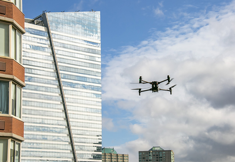
Exterior building conditions are not always easy to see from the ground. Upper facades, roofs, setbacks, courtyards, parapets, and other hard-to-access areas can make early evaluation and documentation difficult before physical access is arranged.
Drone surveys can help close that visibility gap.
Using high-resolution aerial photography, video, photogrammetry / 3D documentation, and, when appropriate, infrared or thermal imaging, drone surveys can support facade evaluations, roof assessments, building envelope surveys, leakage investigations, property condition assessments, repair planning, and construction documentation.
They are not a replacement for every inspection method, but they can be a useful tool within a broader evaluation process, helping project teams document hard-to-access areas and make more informed decisions about follow-up investigation, access planning, repair priorities, or additional testing.
What Are Drone Surveys Used For?
Drone surveys can support a wide range of building evaluation and documentation needs, including:
- Facade evaluations
- Roof assessments
- Building envelope surveys
- Leakage investigations
- Property condition assessments
- FISP / Local Law 11 inspection support
- Parapet, chimney, bulkhead, setback, courtyard, and terrace documentation
- Curtain wall evaluations
- Emergency condition documentation
- Post-incident and insurance-related documentation
- Repair planning and repair documentation
- Construction progress documentation
- Infrared / thermal imaging for roof, facade, and building envelope evaluations
- Photogrammetry / 3D documentation for building exterior conditions
What Building Conditions Can Drone Surveys Document?
Drone surveys are especially useful for exterior areas that are difficult, costly, or disruptive to access during an initial evaluation.
Common areas and conditions documented by drone surveys include:
- Upper facades and difficult-to-access elevations
- Roofs, parapets, chimneys, bulkheads, and mechanical areas
- Setbacks, terraces, courtyards, and obstructed exterior conditions
- Large exterior wall areas
- Conditions near neighboring buildings or tight urban sites
- Visible cracking, staining, displacement, spalling, open mortar joints, deteriorated sealant, corrosion staining, biological growth, or other signs of material distress
- Conditions before, during, and after repair or restoration work
Benefits of Drone Surveys for Building Evaluations
When used as part of a broader building evaluation or inspection strategy, drone surveys can help project teams:
- Improve visibility: Review roofs, upper facades, setbacks, courtyards, and other hard-to-see areas
- Support early evaluation: Document visible conditions before physical access is mobilized
- Strengthen documentation: Provide high-resolution photography, video, and, where useful, photogrammetry / 3D documentation for reports, planning, and project records
- Document project conditions: Capture visible facade, roof, and building envelope conditions before, during, and after repair or restoration work
- Support access planning: Help plan for rope access, suspended scaffolding, boom lifts, probes, or other follow-up access and investigation methods
- Track changes over time: Compare exterior conditions across inspection cycles, repair phases, or future maintenance reviews to support repair planning and capital planning
How Drone Surveys Support Access Planning
For many building evaluations, one of the first challenges is determining how to access the areas that require closer review.
Drone surveys can help project teams review and document visible conditions earlier in the process, particularly on buildings with large facade areas, multiple setbacks, limited rigging locations, courtyards, or conditions obstructed by neighboring structures.
This information can help guide planning for rope access, suspended scaffolding, boom lifts, probes, or other follow-up access and investigation methods depending on the building, scope, and conditions observed.
Drone Use in New York City and the Surrounding Region
Drone operation in New York City requires proper planning and coordination, including FAA-compliant operation and applicable NYC takeoff/landing permits.
Drone surveys outside New York City may be subject to different local requirements, site permissions, airspace restrictions, and property-specific coordination needs.
For building owners and property managers, this means drone surveys should be planned in advance and coordinated with the property, site conditions, applicable regulations, and the intended scope of evaluation.
Can Drones Be Used for FISP / Local Law 11 Inspections?
Drone surveys can support FISP / Local Law 11 inspections by improving visibility, documenting exterior wall conditions, and helping inspection teams plan close-up access.
For buildings with large facade areas, setbacks, difficult access conditions, or complicated facade configurations, drone surveys may help inspection teams review visible exterior conditions before suspended scaffolding, rope access, or other close-up access methods are mobilized.
Current FISP rules still require close-up physical inspections performed under the direction of a Qualified Exterior Wall Inspector (QEWI). Drone surveys support that process but do not replace required hands-on examinations.
Read more: Can Drones Be Used for FISP Inspections in NYC?
Infrared and Thermal Imaging
Drones equipped with infrared or thermal imaging technology can add another layer of information during leakage evaluations, facade investigations, roof assessments, and building envelope surveys.
Thermal imaging can help identify temperature differentials that may be associated with moisture intrusion, air leakage, wet insulation, thermal bridging, or concealed building envelope conditions.
These findings can help guide follow-up investigation, testing, repair planning, or targeted probes, particularly where water infiltration is suspected but not visually obvious.
When Is a Drone Survey Useful?
A drone survey may be worth considering when a property has:
- Large or difficult-to-access facade areas
- Multiple setbacks, terraces, courtyards, or roof levels
- Conditions that are difficult to evaluate from the ground
- Recurring leak complaints or suspected building envelope issues
- A need for repair planning or construction progress documentation
- A need to document conditions before mobilizing more intensive access methods
- A need to communicate visible exterior conditions to owners, boards, managers, or project teams
Frequently Asked Questions About Drone Surveys
Can drone surveys replace hands-on inspections?
Not in all cases. Drone surveys can support visual documentation and planning, but some inspections require close-up physical examination, probes, testing, or other hands-on investigation depending on the building, scope, and applicable requirements.
Can drones be used for FISP / Local Law 11 inspections?
Yes. Drone surveys can support FISP / Local Law 11 inspections by improving visibility, documenting exterior wall conditions, and helping inspection teams plan close-up access. Current FISP rules still require close-up physical inspections performed under the direction of a Qualified Exterior Wall Inspector.
Are drones allowed in New York City?
Yes, but drone operation in New York City requires proper planning and coordination, including FAA-compliant operation and applicable NYC takeoff/landing permits.
Can drone surveys help identify leaks?
Drone surveys can help document visible exterior conditions associated with water infiltration, such as staining, open joints, deteriorated sealant, or roof conditions. When equipped with infrared or thermal imaging, drones can also help identify temperature differentials that may be associated with moisture intrusion, wet insulation, air leakage, or concealed building envelope conditions.
Do drone surveys reduce the need for physical access?
Drone surveys are a visual documentation and planning tool. They can help project teams review hard-to-see exterior conditions before physical access is arranged and may help inform access planning, sequencing, or follow-up investigation.
They do not replace close-up physical inspection where hands-on review is required.
When is a drone survey most useful?
A drone survey may be useful when a building has large exterior wall areas, multiple setbacks, difficult roof or facade access, recurring leak complaints, suspected building envelope issues, or a need to document conditions before repair, restoration, or construction work.
Contact RAND
To find out if your building would benefit from a drone survey, please contact RAND at 212-675-8844 or info@randpc.com.